


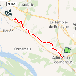
De Saint-Étienne-de-Montluc vers Savenay

phimar_2612
User

Length
15.1 km
Boucle
No
Creation date :
2019-05-04 11:40:33.355
Updated on :
2019-05-04 15:15:47.213
3h26
Difficulty : Medium

FREE GPS app for hiking
 SityTrail
IGN / Geographical institutes
SityTrail Plus
The world is yours!
About
Trail Walking of 15.1 km to be discovered at Pays de la Loire, Loire-Atlantique, Saint-Étienne-de-Montluc. This trail is proposed by phimar_2612.
Description
Sur le GR3
Positioning
Country:
France
Region :
Pays de la Loire
Department/Province :
Loire-Atlantique
Municipality :
Saint-Étienne-de-Montluc
Location:
Unknown
Start:(Dec)
Start:(UTM)
592184 ; 5236812 (30T) N.
Comments