


golignac

FLORENSAC
User

Length
17.2 km

Max alt
666 m

Uphill gradient
623 m
Km-Effort
24 km

Min alt
312 m

Downhill gradient
298 m
Boucle
No
Creation date :
2019-05-05 05:26:46.621
Updated on :
2019-05-05 12:26:04.803
6h20
Difficulty : Very easy

FREE GPS app for hiking
 SityTrail
IGN / Geographical institutes
SityTrail Plus
The world is yours!
About
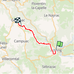
Trail Walking of 17.2 km to be discovered at Occitania, Aveyron, Estaing. This trail is proposed by FLORENSAC.
Positioning
Country:
France
Region :
Occitania
Department/Province :
Aveyron
Municipality :
Estaing
Location:
Unknown
Start:(Dec)
Start:(UTM)
473948 ; 4933379 (31T) N.
Comments