


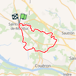
Grande boucle autour de Saint-Étienne-de-Montluc

phimar_2612
User

Length
25 km

Max alt
77 m

Uphill gradient
233 m
Km-Effort
28 km

Min alt
-1 m

Downhill gradient
232 m
Boucle
Yes
Creation date :
2019-05-05 07:23:13.314
Updated on :
2019-05-05 13:56:27.465
6h10
Difficulty : Medium

FREE GPS app for hiking
 SityTrail
IGN / Geographical institutes
SityTrail Plus
The world is yours!
About
Trail Walking of 25 km to be discovered at Pays de la Loire, Loire-Atlantique, Saint-Étienne-de-Montluc. This trail is proposed by phimar_2612.
Description
Suivre le GR3 vers Nantes jusqu'à l'autoroute puis descendre vers la Loire pour enfin zigzaguer vers Saint-Étienne
Photos


Positioning
Country:
France
Region :
Pays de la Loire
Department/Province :
Loire-Atlantique
Municipality :
Saint-Étienne-de-Montluc
Location:
Unknown
Start:(Dec)
Start:(UTM)
592184 ; 5236812 (30T) N.
Comments