Trail Other activity Haut-Intyamon - Lessoc - Chaudzerya - Pertet - La Brâ - Lessoc - Photo

Lessoc - Chaudzerya - Pertet - La Brâ - Lessoc

 fblessoc
fblessoc

User

© OpenStreetMap contributors
Length
Length
10.2 km
Max alt
Max alt
1475 m
Uphill gradient
Uphill gradient
725 m
Km-Effort
Km-Effort  
19.9 km
Min alt
Min alt
818 m
Downhill gradient
Downhill gradient
723 m
Boucle
Boucle
Yes
Creation date :
2014-12-11 00:00:00.0
Updated on :
2014-12-11 00:00:00.0

(0 Reviews)

Other activity
Other activity
--
Difficulty : Unknown

Scan this QR Code to open this trail in the SityTrail application

FREE GPS app for hiking

Logo SityTrail SityTrail

IGN / Geographical institutes

Download SityTrail from the App Store Download SityTrail from Google Play

Logo SityTrail SityTrail World

The world is yours!

Download SityTrail from the App Store Download SityTrail from Google Play Download SityTrail on Huawei AppGallery

About

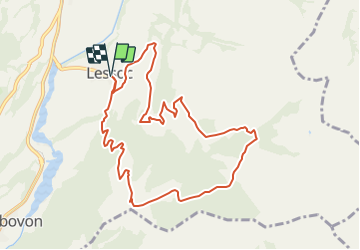
Trail Other activity of 10.2 km to be discovered at Fribourg, Gruyère District. This trail is proposed by fblessoc.

Description

Cette marche se caractérise par son point de vue extraordinaire. Depuis le chalet de La Brâ (1465m), vous serez étonné de voir s''étaler sous vos yeux la quasi totalité du canton de Fribourg.
La Brâ étant inscrite au concept "Préalpes sans frontières", vous pourrez vous y faire servir une boisson par le garde-génisses du moment.
De retour à Lessoc, une bonne fondue à l''Auberge de La Couronne vous fera garder un merveilleux souvenir de cette ballade.

Elevation profile

Positioning

Country:
Switzerland
Region :
Fribourg
Department/Province :
Gruyère District
Municipality :
Haut-Intyamon
Location:
Unknown
Start:(UTM)
351344 ; 5151966 (32T) N.

Trails nearby

Trail Cycle Rossinière - Rossinière - Vevey - Photo
Cycle
karawatsj

Cycle

Very difficult
Rossinière, Vaud, District de la Riviera-Pays-d’Enhaut, Switzerland
88 km | 115 km-effort
5h 56min
No
Trail Walking Haut-Intyamon - st_test3 - Photo
Walking
GUIDE+

Walking

Very easy
Haut-Intyamon, Fribourg, Gruyère District, Switzerland
7.5 km | 11 km-effort
2h 34min
No
Trail Walking Gruyères - st_test3 - Photo
Walking
GUIDE+

Walking

Very easy
Gruyères, Fribourg, Gruyère District, Switzerland
11.2 km | 17.7 km-effort
3h 35min
No
Trail Walking Haut-Intyamon - Comba d’Avau – Montbovon - Photo
Walking
gpiller

Walking

Medium
Haut-Intyamon, Fribourg, Gruyère District, Switzerland
8.1 km | 12 km-effort
2h 30min
Yes
Trail Snowshoes  - Albeuve-Les Avants - Photo
Snowshoes
lroux

Snowshoes

Very easy
, Fribourg, Gruyère District, Switzerland
18.9 km | 35 km-effort
Unknown
No
Trail Other activity  - RAF 2008 - Photo
Other activity
pierrepraz

Other activity

Very easy
, Fribourg, Gruyère District, Switzerland
5 km | 9.5 km-effort
Unknown
No
Trail Walking Grandvillard - Le Vanil Noir par Bounavaux - Photo
Walking
otrement

Walking

Very easy
Grandvillard, Fribourg, Gruyère District, Switzerland
8.6 km | 23 km-effort
4h 40min
Yes
Trail Other activity  - FR - Dent de Lys, Montbovon - Photo
Other activity
sterrettaz

Other activity

Very easy
, Fribourg, Gruyère District, Switzerland
4.2 km | 14 km-effort
Unknown
No
Trail Other activity Rossinière - Rossiniere Allières - Photo
Other activity
lush

Other activity

Very easy
Rossinière, Vaud, District de la Riviera-Pays-d’Enhaut, Switzerland
12.8 km | 24 km-effort
Unknown
No


Close
My subscriptions