


gernelle

lousim22
User
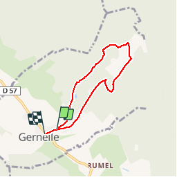

Length
5.3 km

Max alt
262 m

Uphill gradient
99 m
Km-Effort
6.6 km

Min alt
188 m

Downhill gradient
98 m
Boucle
No
Creation date :
2019-05-06 12:03:01.834
Updated on :
2019-05-06 13:58:56.572
1h57
Difficulty : Very easy

FREE GPS app for hiking
 SityTrail
IGN / Geographical institutes
SityTrail Plus
The world is yours!
About
Trail Walking of 5.3 km to be discovered at Grand Est, Ardennes, Gernelle. This trail is proposed by lousim22.
Positioning
Country:
France
Region :
Grand Est
Department/Province :
Ardennes
Municipality :
Gernelle
Location:
Unknown
Start:(Dec)
Start:(UTM)
631095 ; 5514445 (31U) N.
Comments