


ROYAT 19/04/2019

walrou63
User
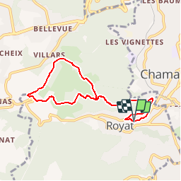

Length
7.8 km

Max alt
740 m

Uphill gradient
258 m
Km-Effort
11.2 km

Min alt
479 m

Downhill gradient
253 m
Boucle
Yes
Creation date :
2019-05-07 08:40:17.877
Updated on :
2019-05-07 08:42:30.829
2h21
Difficulty : Medium

FREE GPS app for hiking
 SityTrail
IGN / Geographical institutes
SityTrail Plus
The world is yours!
About
Trail Walking of 7.8 km to be discovered at Auvergne-Rhône-Alpes, Puy-de-Dôme, Royat. This trail is proposed by walrou63.
Positioning
Country:
France
Region :
Auvergne-Rhône-Alpes
Department/Province :
Puy-de-Dôme
Municipality :
Royat
Location:
Unknown
Start:(Dec)
Start:(UTM)
503974 ; 5067948 (31T) N.
Comments