


rocher de Roquebrune avec Agnès et Jean-Claude le 7 mai 2019

gillou1947
User
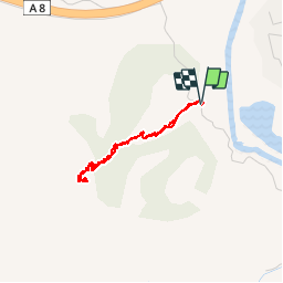

Length
2.8 km

Max alt
333 m

Uphill gradient
315 m
Km-Effort
7 km

Min alt
13 m

Downhill gradient
315 m
Boucle
Yes
Creation date :
2019-05-07 09:02:15.633
Updated on :
2019-05-07 12:57:03.24
2h43
Difficulty : Very easy

FREE GPS app for hiking
 SityTrail
IGN / Geographical institutes
SityTrail Plus
The world is yours!
About
Trail Walking of 2.8 km to be discovered at Provence-Alpes-Côte d'Azur, Var, Roquebrune-sur-Argens. This trail is proposed by gillou1947.
Positioning
Country:
France
Region :
Provence-Alpes-Côte d'Azur
Department/Province :
Var
Municipality :
Roquebrune-sur-Argens
Location:
Unknown
Start:(Dec)
Start:(UTM)
306861 ; 4813973 (32T) N.
Comments