


Roquebrune nord

aljac
User
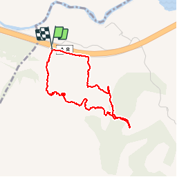

Length
3.6 km

Max alt
175 m

Uphill gradient
186 m
Km-Effort
6.1 km

Min alt
16 m

Downhill gradient
192 m
Boucle
Yes
Creation date :
2019-05-07 12:10:10.491
Updated on :
2019-05-07 14:32:45.128
2h22
Difficulty : Very easy

FREE GPS app for hiking
 SityTrail
IGN / Geographical institutes
SityTrail Plus
The world is yours!
About
Trail Walking of 3.6 km to be discovered at Provence-Alpes-Côte d'Azur, Var, Roquebrune-sur-Argens. This trail is proposed by aljac.
Positioning
Country:
France
Region :
Provence-Alpes-Côte d'Azur
Department/Province :
Var
Municipality :
Roquebrune-sur-Argens
Location:
Unknown
Start:(Dec)
Start:(UTM)
305715 ; 4814623 (32T) N.
Comments