


2019 05 07

lr80
User
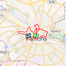

Length
12.9 km

Max alt
45 m

Uphill gradient
92 m
Km-Effort
14.2 km

Min alt
19 m

Downhill gradient
92 m
Boucle
Yes
Creation date :
2019-05-07 05:55:09.296
Updated on :
2019-05-08 06:16:13.529
2h06
Difficulty : Easy

FREE GPS app for hiking
 SityTrail
IGN / Geographical institutes
SityTrail Plus
The world is yours!
About
Trail Walking of 12.9 km to be discovered at Hauts-de-France, Somme, Amiens. This trail is proposed by lr80.
Description
tour du jour
Positioning
Country:
France
Region :
Hauts-de-France
Department/Province :
Somme
Municipality :
Amiens
Location:
Unknown
Start:(Dec)
Start:(UTM)
449033 ; 5526808 (31U) N.
Comments