


RS-Les 13 Fontaines

raymondfn
User
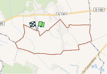

Length
4.8 km

Max alt
411 m

Uphill gradient
43 m
Km-Effort
5.4 km

Min alt
381 m

Downhill gradient
45 m
Boucle
Yes
Creation date :
2019-05-08 15:31:17.206
Updated on :
2019-05-15 13:51:15.021
1h11
Difficulty : Easy

FREE GPS app for hiking
 SityTrail
IGN / Geographical institutes
SityTrail Plus
The world is yours!
About
Trail Walking of 4.8 km to be discovered at Auvergne-Rhône-Alpes, Isère, Brézins. This trail is proposed by raymondfn.
Description
Depuis Brézins, Ferme des 13 Fontaines.
Boucle sans difficultés.
Positioning
Country:
France
Region :
Auvergne-Rhône-Alpes
Department/Province :
Isère
Municipality :
Brézins
Location:
Unknown
Start:(Dec)
Start:(UTM)
680849 ; 5022584 (31T) N.
Comments