


Egaules

sauvat
User
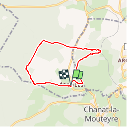

Length
5.9 km

Max alt
847 m

Uphill gradient
126 m
Km-Effort
7.6 km

Min alt
725 m

Downhill gradient
125 m
Boucle
Yes
Creation date :
2019-05-09 09:41:24.615
Updated on :
2019-05-09 09:42:44.832
1h38
Difficulty : Medium

FREE GPS app for hiking
 SityTrail
IGN / Geographical institutes
SityTrail Plus
The world is yours!
About
Trail Walking of 5.9 km to be discovered at Auvergne-Rhône-Alpes, Puy-de-Dôme, Volvic. This trail is proposed by sauvat.
Description
A partir de Egaules Balirando raccourcie à 6km
Positioning
Country:
France
Region :
Auvergne-Rhône-Alpes
Department/Province :
Puy-de-Dôme
Municipality :
Volvic
Location:
Unknown
Start:(Dec)
Start:(UTM)
500370 ; 5075960 (31T) N.
Comments