Trail Mountain bike Nasbinals - 2. La cascade du Déroc - Photo

2. La cascade du Déroc

 benoit48
benoit48

User

© OpenStreetMap contributors
Length
Length
20 km
Max alt
Max alt
1225 m
Uphill gradient
Uphill gradient
333 m
Km-Effort
Km-Effort  
24 km
Min alt
Min alt
1136 m
Downhill gradient
Downhill gradient
334 m
Boucle
Boucle
Yes
Creation date :
2019-05-09 20:24:49.303
Updated on :
2019-05-09 20:28:27.894

(0 Reviews)

Mountain bike
Mountain bike
1h36
Difficulty : Medium

Scan this QR Code to open this trail in the SityTrail application

FREE GPS app for hiking

Logo SityTrail SityTrail

IGN / Geographical institutes

Download SityTrail from the App Store Download SityTrail from Google Play

Logo SityTrail SityTrail Plus

The world is yours!

Download SityTrail from the App Store Download SityTrail from Google Play Download SityTrail on Huawei AppGallery

About

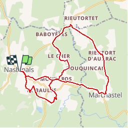
Trail Mountain bike of 20 km to be discovered at Occitania, Lozère, Nasbinals. This trail is proposed by benoit48.

Elevation profile

Points of interest

Point of interest Nasbinals - 2-03 - Photo
benoit48
NASBINALS 
Point of interest Marchastel - 2-02 - Photo
benoit48
MARCHASTEL 
Point of interest Nasbinals - 2-01 - Photo
benoit48
NASBINALS 
Point of interest Nasbinals - 2-00 - Photo
benoit48
NASBINALS 

Positioning

Country:
France
Region :
Occitania
Department/Province :
Lozère
Municipality :
Nasbinals
Location:
Unknown
Start:(UTM)
503764 ; 4945381 (31T) N.


Close
My subscriptions