


pont saint esprid

mthomas30
User
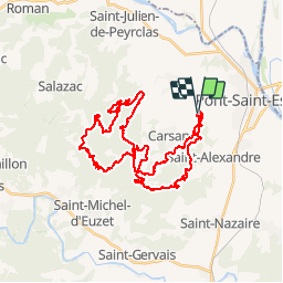

Length
41 km

Max alt
358 m

Uphill gradient
1058 m
Km-Effort
55 km

Min alt
113 m

Downhill gradient
1052 m
Boucle
Yes
Creation date :
2019-05-12 05:36:59.208
Updated on :
2019-05-12 10:00:54.639
4h22
Difficulty : Easy

FREE GPS app for hiking
 SityTrail
IGN / Geographical institutes
SityTrail Plus
The world is yours!
About
Trail Mountain bike of 41 km to be discovered at Occitania, Gard, Pont-Saint-Esprit. This trail is proposed by mthomas30.
Positioning
Country:
France
Region :
Occitania
Department/Province :
Gard
Municipality :
Pont-Saint-Esprit
Location:
Unknown
Start:(Dec)
Start:(UTM)
628673 ; 4900639 (31T) N.
Comments