Trail Walking Villers-sur-Saulnot - 4 - Villers-sur-Saulnot Villersexel - Photo

4 - Villers-sur-Saulnot Villersexel

© OpenStreetMap contributors
Length
Length
25 km
Max alt
Max alt
407 m
Uphill gradient
Uphill gradient
333 m
Km-Effort
Km-Effort  
30 km
Min alt
Min alt
262 m
Downhill gradient
Downhill gradient
445 m
Boucle
Boucle
No
Creation date :
2019-05-12 11:11:45.499
Updated on :
2019-05-12 16:34:27.857

(0 Reviews)

Walking
Walking
6h26
Difficulty : Very difficult

Scan this QR Code to open this trail in the SityTrail application

FREE GPS app for hiking

Logo SityTrail SityTrail

IGN / Geographical institutes

Download SityTrail from the App Store Download SityTrail from Google Play

Logo SityTrail SityTrail World

The world is yours!

Download SityTrail from the App Store Download SityTrail from Google Play Download SityTrail on Huawei AppGallery

About

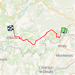
Trail Walking of 25 km to be discovered at Bourgogne-Franche-Comté, Haute-Saône, Villers-sur-Saulnot. This trail is proposed by randovoujo.

Description

Parcour à faire en plusieurs étapes, voir les parcours : Chemin de St Jacques

Elevation profile

Positioning

Country:
France
Region :
Bourgogne-Franche-Comté
Department/Province :
Haute-Saône
Municipality :
Villers-sur-Saulnot
Location:
Unknown
Start:(UTM)
323079 ; 5269030 (32T) N.

Trails nearby

Trail Walking Trémoins - TREMOINS - Photo
Walking
Marchebuissonniere

Walking

Medium
(1)
Trémoins, Bourgogne-Franche-Comté, Haute-Saône, France
8.3 km | 10.5 km-effort
3h 22min
Yes
Trail Walking Champey - champey - Photo
Walking
Fillatre

Walking

Difficult
(1)
Champey, Bourgogne-Franche-Comté, Haute-Saône, France
12.6 km | 16.5 km-effort
3h 37min
Yes
Trail Walking Marvelise - Marvelise - Photo
Walking
ISATR

Walking

Easy
Marvelise, Bourgogne-Franche-Comté, Doubs, France
7.8 km | 10.2 km-effort
2h 36min
Yes
Trail Mountain bike Semondans - les  valettes - Photo
Mountain bike
Raphaël K

Mountain bike

Very difficult
Semondans, Bourgogne-Franche-Comté, Doubs, France
34 km | 44 km-effort
2h 11min
Yes
Trail Mountain bike Semondans - menhir de Brevilliers  - Photo
Mountain bike
Raphaël K

Mountain bike

Very difficult
Semondans, Bourgogne-Franche-Comté, Doubs, France
41 km | 50 km-effort
3h 3min
Yes
Trail Walking Champey - grotte de la Baume - Photo
Walking
Raymond Bacholle

Walking

Easy
Champey, Bourgogne-Franche-Comté, Haute-Saône, France
21 km | 27 km-effort
4h 45min
Yes
Trail Mountain bike Semondans - mont vaudois  - Photo
Mountain bike
Raphaël K

Mountain bike

Medium
Semondans, Bourgogne-Franche-Comté, Doubs, France
29 km | 37 km-effort
1h 47min
Yes
Trail Mountain bike Semondans - val de bonnal - Photo
Mountain bike
Raphaël K

Mountain bike

Very difficult
Semondans, Bourgogne-Franche-Comté, Doubs, France
43 km | 56 km-effort
3h 29min
No
Trail Walking Saint-Julien-lès-Montbéliard - St julien 160621 - Photo
Walking
GUIDE
David25400

Walking

Very easy
Saint-Julien-lès-Montbéliard, Bourgogne-Franche-Comté, Doubs, France
6.3 km | 8.2 km-effort
1h 54min
Yes


Close
My subscriptions