


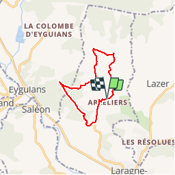
Balcons du Laragnais

claude nier
User

Length
11.3 km
Boucle
Yes
Creation date :
2019-05-12 08:21:15.504
Updated on :
2019-05-12 13:42:39.332
3h36
Difficulty : Easy

FREE GPS app for hiking
 SityTrail
IGN / Geographical institutes
SityTrail Plus
The world is yours!
About
Trail Walking of 11.3 km to be discovered at Provence-Alpes-Côte d'Azur, Hautes-Alpes, Laragne-Montéglin. This trail is proposed by claude nier.
Description
Reco Aline et Moi
Magnifique ....
Positioning
Country:
France
Region :
Provence-Alpes-Côte d'Azur
Department/Province :
Hautes-Alpes
Municipality :
Laragne-Montéglin
Location:
Unknown
Start:(Dec)
Start:(UTM)
724136 ; 4913742 (31T) N.
Comments