


Casteljau

Thomasdanielle
User

Length
10 km

Max alt
241 m

Uphill gradient
391 m
Km-Effort
15.2 km

Min alt
119 m

Downhill gradient
390 m
Boucle
Yes
Creation date :
2019-05-12 07:51:28.0
Updated on :
2019-05-12 14:33:46.243
4h59
Difficulty : Very difficult

FREE GPS app for hiking
 SityTrail
IGN / Geographical institutes
SityTrail Plus
The world is yours!
About
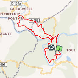
Trail Walking of 10 km to be discovered at Auvergne-Rhône-Alpes, Ardèche, Berrias-et-Casteljau. This trail is proposed by Thomasdanielle.
Description
Super 10,3 l
Positioning
Country:
France
Region :
Auvergne-Rhône-Alpes
Department/Province :
Ardèche
Municipality :
Berrias-et-Casteljau
Location:
Casteljau
Start:(Dec)
Start:(UTM)
595434 ; 4916867 (31T) N.
Comments