


Saint-Quinis - chemin du pélérinage et bords de l'Issole

frizou83
User
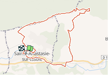

Length
11.3 km

Max alt
595 m

Uphill gradient
385 m
Km-Effort
16.4 km

Min alt
264 m

Downhill gradient
385 m
Boucle
Yes
Creation date :
2019-05-12 18:50:58.246
Updated on :
2024-12-29 10:37:35.904
3h43
Difficulty : Difficult

FREE GPS app for hiking
 SityTrail
IGN / Geographical institutes
SityTrail Plus
The world is yours!
About
Trail Walking of 11.3 km to be discovered at Provence-Alpes-Côte d'Azur, Var, Sainte-Anastasie-sur-Issole. This trail is proposed by frizou83.
Positioning
Country:
France
Region :
Provence-Alpes-Côte d'Azur
Department/Province :
Var
Municipality :
Sainte-Anastasie-sur-Issole
Location:
Unknown
Start:(Dec)
Start:(UTM)
266723 ; 4802901 (32T) N.
Comments