


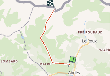
col de Rasis

oliviergau
User

Length
7.1 km

Max alt
2920 m

Uphill gradient
1149 m
Km-Effort
18.8 km

Min alt
1824 m

Downhill gradient
66 m
Boucle
No
Creation date :
2019-05-12 20:06:48.095
Updated on :
2019-05-12 20:06:48.095
--
Difficulty : Unknown

FREE GPS app for hiking
 SityTrail
IGN / Geographical institutes
SityTrail Plus
The world is yours!
About
Trail Touring skiing of 7.1 km to be discovered at Provence-Alpes-Côte d'Azur, Hautes-Alpes, Abriès-Ristolas. This trail is proposed by oliviergau.
Positioning
Country:
France
Region :
Provence-Alpes-Côte d'Azur
Department/Province :
Hautes-Alpes
Municipality :
Abriès-Ristolas
Location:
Abriès
Start:(Dec)
Start:(UTM)
335636 ; 4962744 (32T) N.
Comments