


COL SANGUINIERE

oliviergau
User
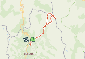

Length
13.5 km

Max alt
2849 m

Uphill gradient
1009 m
Km-Effort
27 km

Min alt
1842 m

Downhill gradient
1012 m
Boucle
Yes
Creation date :
2019-05-12 20:07:12.11
Updated on :
2019-05-12 20:07:12.11
--
Difficulty : Unknown

FREE GPS app for hiking
 SityTrail
IGN / Geographical institutes
SityTrail Plus
The world is yours!
About
Trail Touring skiing of 13.5 km to be discovered at Provence-Alpes-Côte d'Azur, Maritime Alps, Entraunes. This trail is proposed by oliviergau.
Positioning
Country:
France
Region :
Provence-Alpes-Côte d'Azur
Department/Province :
Maritime Alps
Municipality :
Entraunes
Location:
Unknown
Start:(Dec)
Start:(UTM)
320782 ; 4901317 (32T) N.
Comments