


L'arche double de Chartreuse

oliviergau
User
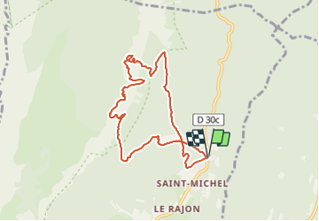

Length
8.5 km

Max alt
1887 m

Uphill gradient
1131 m
Km-Effort
24 km

Min alt
1069 m

Downhill gradient
1130 m
Boucle
Yes
Creation date :
2019-05-12 20:13:13.896
Updated on :
2019-05-12 20:13:13.896
--
Difficulty : Unknown

FREE GPS app for hiking
 SityTrail
IGN / Geographical institutes
SityTrail Plus
The world is yours!
About
Trail Touring skiing of 8.5 km to be discovered at Auvergne-Rhône-Alpes, Isère, Plateau-des-Petites-Roches. This trail is proposed by oliviergau.
Positioning
Country:
France
Region :
Auvergne-Rhône-Alpes
Department/Province :
Isère
Municipality :
Plateau-des-Petites-Roches
Location:
Saint-Bernard
Start:(Dec)
Start:(UTM)
728604 ; 5026543 (31T) N.
Comments