


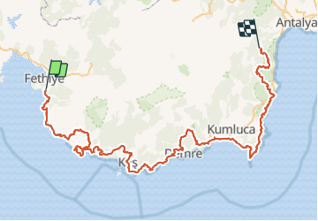
LycianWay.gpx

oliviergau
User

Length
438 km

Max alt
1777 m

Uphill gradient
17100 m
Km-Effort
664 km

Min alt
-7 m

Downhill gradient
16545 m
Boucle
No
Creation date :
2019-05-12 20:13:41.392
Updated on :
2019-05-12 20:13:41.392
--
Difficulty : Unknown

FREE GPS app for hiking
 SityTrail
IGN / Geographical institutes
SityTrail Plus
The world is yours!
About
Trail Touring skiing of 438 km to be discovered at Muğla, Fethiye. This trail is proposed by oliviergau.
Positioning
Country:
Turkey
Region :
Muğla
Department/Province :
Fethiye
Municipality :
Karakeçililer
Location:
Unknown
Start:(Dec)
Start:(UTM)
691522 ; 4049340 (35S) N.
Comments