


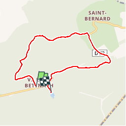
balade de l'étang aux moines.

breton111
User

Length
6.8 km

Max alt
317 m

Uphill gradient
152 m
Km-Effort
8.7 km

Min alt
225 m

Downhill gradient
129 m
Boucle
No
Creation date :
2019-05-12 13:26:10.428
Updated on :
2019-05-13 04:30:23.802
1h54
Difficulty : Very easy

FREE GPS app for hiking
 SityTrail
IGN / Geographical institutes
SityTrail Plus
The world is yours!
About
Trail Walking of 6.8 km to be discovered at Grand Est, Moselle, Saint-Hubert. This trail is proposed by breton111.
Positioning
Country:
France
Region :
Grand Est
Department/Province :
Moselle
Municipality :
Saint-Hubert
Location:
Unknown
Start:(Dec)
Start:(UTM)
307950 ; 5456690 (32U) N.
Comments