


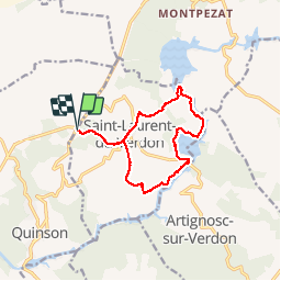
St Laurent du Verdon

philcll
User

Length
13.5 km

Max alt
561 m

Uphill gradient
292 m
Km-Effort
17.4 km

Min alt
404 m

Downhill gradient
293 m
Boucle
Yes
Creation date :
2019-05-13 08:27:16.602
Updated on :
2019-05-16 16:20:37.284
6h50
Difficulty : Medium

FREE GPS app for hiking
 SityTrail
IGN / Geographical institutes
SityTrail Plus
The world is yours!
About
Trail Walking of 13.5 km to be discovered at Provence-Alpes-Côte d'Azur, Alpes-de-Haute-Provence, Saint-Laurent-du-Verdon. This trail is proposed by philcll.
Description
Descente du St-Laurent depuis le plateau puis boucle Verdon / Lac d'Artignosc autour de St-Laurent (randonnée
Positioning
Country:
France
Region :
Provence-Alpes-Côte d'Azur
Department/Province :
Alpes-de-Haute-Provence
Municipality :
Saint-Laurent-du-Verdon
Location:
Unknown
Start:(Dec)
Start:(UTM)
262532 ; 4845603 (32T) N.
Comments