Trail Walking Forcalquier - 20190513. Tour de Forcalquier à pied.  - Photo
 hal2012
hal2012

User

© OpenStreetMap contributors
Length
Length
6.1 km
Max alt
Max alt
607 m
Uphill gradient
Uphill gradient
166 m
Km-Effort
Km-Effort  
8.3 km
Min alt
Min alt
537 m
Downhill gradient
Downhill gradient
164 m
Boucle
Boucle
Yes
Creation date :
2019-05-13 13:07:37.72
Updated on :
2019-05-13 18:13:20.472

(0 Reviews)

Walking
Walking
4h59
Difficulty : Very easy

Scan this QR Code to open this trail in the SityTrail application

FREE GPS app for hiking

Logo SityTrail SityTrail

IGN / Geographical institutes

Download SityTrail from the App Store Download SityTrail from Google Play

Logo SityTrail SityTrail Plus

The world is yours!

Download SityTrail from the App Store Download SityTrail from Google Play Download SityTrail on Huawei AppGallery

About

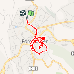
Trail Walking of 6.1 km to be discovered at Provence-Alpes-Côte d'Azur, Alpes-de-Haute-Provence, Forcalquier. This trail is proposed by hal2012.

Description

Départ 15h05
Tour de la ville....
...
Salon de thé 18h30... 18h45
Café et thé gourmands (6   7€)
Sirop gingembre (2€)
Total 15€
Retour à la Citadelle...
Retour maison 20h05.

Elevation profile

Photos

32 photos in total. Please click on a photo to see them all in the gallery.

Positioning

Country:
France
Region :
Provence-Alpes-Côte d'Azur
Department/Province :
Alpes-de-Haute-Provence
Municipality :
Forcalquier
Location:
Unknown
Start:(UTM)
722882 ; 4871534 (31T) N.


Close
My subscriptions