


Sortie validation Saint Jorioz 2019

JPS73
User
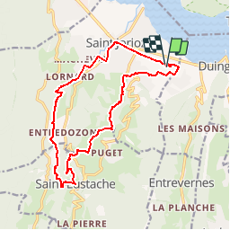

Length
16.3 km

Max alt
742 m

Uphill gradient
454 m
Km-Effort
22 km

Min alt
458 m

Downhill gradient
457 m
Boucle
Yes
Creation date :
2019-05-13 19:31:09.641
Updated on :
2019-05-13 19:33:01.649
--
Difficulty : Very easy

FREE GPS app for hiking
 SityTrail
IGN / Geographical institutes
SityTrail Plus
The world is yours!
About
Trail On foot of 16.3 km to be discovered at Auvergne-Rhône-Alpes, Upper Savoy, Saint-Jorioz. This trail is proposed by JPS73.
Positioning
Country:
France
Region :
Auvergne-Rhône-Alpes
Department/Province :
Upper Savoy
Municipality :
Saint-Jorioz
Location:
Unknown
Start:(Dec)
Start:(UTM)
281232 ; 5078707 (32T) N.
Comments