


SityTrail - Pic du Taoumé

LouisROGER
User GUIDE
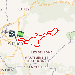

Length
11.5 km

Max alt
662 m

Uphill gradient
549 m
Km-Effort
18.9 km

Min alt
235 m

Downhill gradient
551 m
Boucle
Yes
Creation date :
2019-05-14 08:36:02.799
Updated on :
2019-05-14 08:36:21.522
3h52
Difficulty : Difficult

FREE GPS app for hiking
 SityTrail
IGN / Geographical institutes
SityTrail Plus
The world is yours!
About
Trail Walking of 11.5 km to be discovered at Provence-Alpes-Côte d'Azur, Bouches-du-Rhône, Allauch. This trail is proposed by LouisROGER.
Positioning
Country:
France
Region :
Provence-Alpes-Côte d'Azur
Department/Province :
Bouches-du-Rhône
Municipality :
Allauch
Location:
Unknown
Start:(Dec)
Start:(UTM)
701412 ; 4801321 (31T) N.
Comments