


Essomes du 14-05-2019

VANDERPUTTENMi
User GUIDE

Length
8.2 km

Max alt
207 m

Uphill gradient
203 m
Km-Effort
10.9 km

Min alt
63 m

Downhill gradient
202 m
Boucle
Yes
Creation date :
2019-05-14 11:38:44.932
Updated on :
2019-05-17 20:13:12.179
2h38
Difficulty : Very easy

FREE GPS app for hiking
 SityTrail
IGN / Geographical institutes
SityTrail Plus
The world is yours!
About
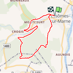
Trail Walking of 8.2 km to be discovered at Hauts-de-France, Aisne, Essômes-sur-Marne. This trail is proposed by VANDERPUTTENMi.
Positioning
Country:
France
Region :
Hauts-de-France
Department/Province :
Aisne
Municipality :
Essômes-sur-Marne
Location:
Unknown
Start:(Dec)
Start:(UTM)
527128 ; 5430969 (31U) N.
Comments