


blamont

tiene
User

Length
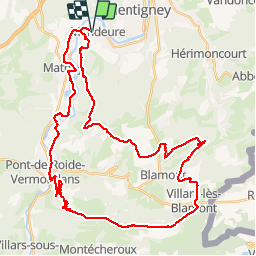
47 km

Max alt
834 m

Uphill gradient
924 m
Km-Effort
59 km

Min alt
331 m

Downhill gradient
924 m
Boucle
Yes
Creation date :
2019-05-14 11:12:53.678
Updated on :
2019-05-14 15:43:01.65
4h22
Difficulty : Very easy

FREE GPS app for hiking
 SityTrail
IGN / Geographical institutes
SityTrail Plus
The world is yours!
About
Trail Mountain bike of 47 km to be discovered at Bourgogne-Franche-Comté, Doubs, Mandeure. This trail is proposed by tiene.
Description
dggh
Positioning
Country:
France
Region :
Bourgogne-Franche-Comté
Department/Province :
Doubs
Municipality :
Mandeure
Location:
Unknown
Start:(Dec)
Start:(UTM)
334309 ; 5257744 (32T) N.
Comments