


mont frech Murat

CASSISFRAMBOISE
User
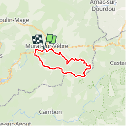

Length
19.9 km

Max alt
1163 m

Uphill gradient
522 m
Km-Effort
27 km

Min alt
826 m

Downhill gradient
525 m
Boucle
Yes
Creation date :
2019-05-14 07:21:22.257
Updated on :
2019-05-14 18:37:10.425
4h59
Difficulty : Very easy

FREE GPS app for hiking
 SityTrail
IGN / Geographical institutes
SityTrail Plus
The world is yours!
About
Trail Walking of 19.9 km to be discovered at Occitania, Tarn, Murat-sur-Vèbre. This trail is proposed by CASSISFRAMBOISE.
Description
belle rando entre hetres et sapins. 19.9 kms et 520 m D
Positioning
Country:
France
Region :
Occitania
Department/Province :
Tarn
Municipality :
Murat-sur-Vèbre
Location:
Unknown
Start:(Dec)
Start:(UTM)
487936 ; 4836429 (31T) N.
Comments