


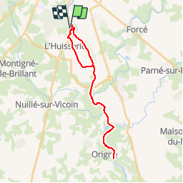
De L'Huisserie à Origné le long de la Mayenne

phimar_2612
User

Length
26 km

Max alt
109 m

Uphill gradient
361 m
Km-Effort
31 km

Min alt
34 m

Downhill gradient
361 m
Boucle
Yes
Creation date :
2019-05-12 09:15:43.965
Updated on :
2019-05-15 09:22:38.015
5h25
Difficulty : Easy

FREE GPS app for hiking
 SityTrail
IGN / Geographical institutes
SityTrail Plus
The world is yours!
About
Trail Walking of 26 km to be discovered at Pays de la Loire, Mayenne, L'Huisserie. This trail is proposed by phimar_2612.
Positioning
Country:
France
Region :
Pays de la Loire
Department/Province :
Mayenne
Municipality :
L'Huisserie
Location:
Unknown
Start:(Dec)
Start:(UTM)
666797 ; 5322559 (30U) N.
Comments