


les Bennevises 88

cousam
User
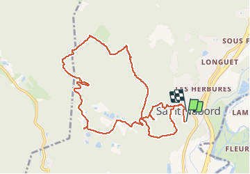

Length
10.9 km

Max alt
634 m

Uphill gradient
374 m
Km-Effort
16.1 km

Min alt
412 m

Downhill gradient
435 m
Boucle
Yes
Creation date :
2019-05-15 12:04:06.276
Updated on :
2021-04-12 19:19:06.544
2h44
Difficulty : Very easy

FREE GPS app for hiking
 SityTrail
IGN / Geographical institutes
SityTrail Plus
The world is yours!
About
Trail Walking of 10.9 km to be discovered at Grand Est, Vosges, Saint-Nabord. This trail is proposed by cousam.
Positioning
Country:
France
Region :
Grand Est
Department/Province :
Vosges
Municipality :
Saint-Nabord
Location:
Unknown
Start:(Dec)
Start:(UTM)
319468 ; 5324223 (32U) N.
Comments