


11_Comus_Montségur_J8

jab31
User
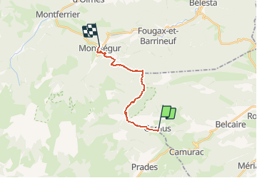

Length
14.8 km

Max alt
1196 m

Uphill gradient
547 m
Km-Effort
23 km

Min alt
608 m

Downhill gradient
825 m
Boucle
No
Creation date :
2019-05-14 06:16:20.741
Updated on :
2020-02-10 09:27:40.756
6h24
Difficulty : Medium

FREE GPS app for hiking
 SityTrail
IGN / Geographical institutes
SityTrail Plus
The world is yours!
About
Trail Walking of 14.8 km to be discovered at Occitania, Aude, Comus. This trail is proposed by jab31.
Description
Passage par les gorges de la Frau.
Montée vers Montségur et le Pays d'Olmes.
Positioning
Country:
France
Region :
Occitania
Department/Province :
Aude
Municipality :
Comus
Location:
Unknown
Start:(Dec)
Start:(UTM)
409307 ; 4740703 (31T) N.
Comments