


Moussy du 16/05/2019

VANDERPUTTENMi
User GUIDE

Length
19.5 km

Max alt
238 m

Uphill gradient
419 m
Km-Effort
25 km

Min alt
91 m

Downhill gradient
419 m
Boucle
Yes
Creation date :
2019-05-16 07:57:31.585
Updated on :
2019-05-19 17:30:25.391
5h32
Difficulty : Very easy

FREE GPS app for hiking
 SityTrail
IGN / Geographical institutes
SityTrail Plus
The world is yours!
About
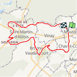
Trail Walking of 19.5 km to be discovered at Grand Est, Marne, Moussy. This trail is proposed by VANDERPUTTENMi.
Positioning
Country:
France
Region :
Grand Est
Department/Province :
Marne
Municipality :
Moussy
Location:
Unknown
Start:(Dec)
Start:(UTM)
567404 ; 5429319 (31U) N.
Comments