


col des glacières_le Latay (variante Claude)

bernir
User
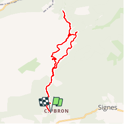

Length
18 km

Max alt
866 m

Uphill gradient
549 m
Km-Effort
25 km

Min alt
424 m

Downhill gradient
547 m
Boucle
Yes
Creation date :
2019-05-16 07:17:32.372
Updated on :
2019-05-17 07:44:35.907
7h37
Difficulty : Medium

FREE GPS app for hiking
 SityTrail
IGN / Geographical institutes
SityTrail Plus
The world is yours!
About
Trail Walking of 18 km to be discovered at Provence-Alpes-Côte d'Azur, Var, Signes. This trail is proposed by bernir.
Positioning
Country:
France
Region :
Provence-Alpes-Côte d'Azur
Department/Province :
Var
Municipality :
Signes
Location:
Unknown
Start:(Dec)
Start:(UTM)
729063 ; 4796682 (31T) N.
Comments