


SityTrail - 818889 - st-aubin

doboul
User
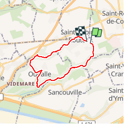

Length
10.6 km

Max alt
117 m

Uphill gradient
187 m
Km-Effort
13.1 km

Min alt
9 m

Downhill gradient
193 m
Boucle
Yes
Creation date :
2019-05-16 14:59:40.346
Updated on :
2019-05-16 14:59:40.346
--
Difficulty : Unknown

FREE GPS app for hiking
 SityTrail
IGN / Geographical institutes
SityTrail Plus
The world is yours!
About
Trail Walking of 10.6 km to be discovered at Normandy, Seine-Maritime, Saint-Aubin-Routot. This trail is proposed by doboul.
Positioning
Country:
France
Region :
Normandy
Department/Province :
Seine-Maritime
Municipality :
Saint-Aubin-Routot
Location:
Unknown
Start:(Dec)
Start:(UTM)
307103 ; 5488575 (31U) N.
Comments