


SityTrail - 1019295 - st-vincent-cramesnil

doboul
User
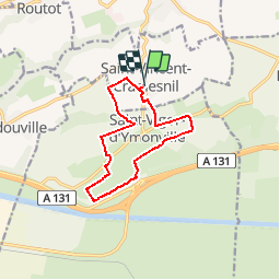

Length
10.4 km

Max alt
118 m

Uphill gradient
93 m
Km-Effort
11.7 km

Min alt
62 m

Downhill gradient
92 m
Boucle
Yes
Creation date :
2019-05-16 15:00:43.328
Updated on :
2019-05-16 15:00:43.328
--
Difficulty : Unknown

FREE GPS app for hiking
 SityTrail
IGN / Geographical institutes
SityTrail Plus
The world is yours!
About
Trail Walking of 10.4 km to be discovered at Normandy, Seine-Maritime, Saint-Vincent-Cramesnil. This trail is proposed by doboul.
Positioning
Country:
France
Region :
Normandy
Department/Province :
Seine-Maritime
Municipality :
Saint-Vincent-Cramesnil
Location:
Unknown
Start:(Dec)
Start:(UTM)
308841 ; 5486942 (31U) N.
Comments