Trail Walking Vézeronce-Curtin - Vignieu - Photo
 cricri34
cricri34

User

© OpenStreetMap contributors
Length
Length
11.7 km
Max alt
Max alt
444 m
Uphill gradient
Uphill gradient
279 m
Km-Effort
Km-Effort  
15.4 km
Min alt
Min alt
221 m
Downhill gradient
Downhill gradient
279 m
Boucle
Boucle
Yes
Creation date :
2019-05-16 12:04:57.024
Updated on :
2019-05-16 15:28:05.98

(0 Reviews)

Walking
Walking
3h18
Difficulty : Medium

Scan this QR Code to open this trail in the SityTrail application

FREE GPS app for hiking

Logo SityTrail SityTrail

IGN / Geographical institutes

Download SityTrail from the App Store Download SityTrail from Google Play

Logo SityTrail SityTrail World

The world is yours!

Download SityTrail from the App Store Download SityTrail from Google Play Download SityTrail on Huawei AppGallery

About

Trail Walking of 11.7 km to be discovered at Auvergne-Rhône-Alpes, Isère, Vézeronce-Curtin. This trail is proposed by cricri34.

Description

Pas trop difficile, juste une bonne montée à mi-chemin.

Elevation profile

Positioning

Country:
France
Region :
Auvergne-Rhône-Alpes
Department/Province :
Isère
Municipality :
Vézeronce-Curtin
Location:
Unknown
Start:(UTM)
690137 ; 5057762 (31T) N.

Trails nearby

Trail Motor Arandon-Passins - Rando avec Rémi - Photo
Motor
mouth

Motor

Easy
(1)
Arandon-Passins, Auvergne-Rhône-Alpes, Isère, France
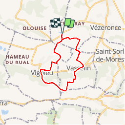
57 km | 63 km-effort
3h 47min
No
Trail Mountain bike Morestel - Tour de Morestel - Photo
Mountain bike
vincen

Mountain bike

Very easy
(2)
Morestel, Auvergne-Rhône-Alpes, Isère, France
48 km | 56 km-effort
Unknown
Yes
Trail Mountain bike Morestel - morestel pont d'evieux - Photo
Mountain bike
THIERRY.GADEN

Mountain bike

Medium
Morestel, Auvergne-Rhône-Alpes, Isère, France
27 km | 29 km-effort
3h 4min
No
Trail Other activity Morestel - randonnée des lavoirs de Vézeronce-Curtin  - Photo
Other activity
thethys

Other activity

Easy
Morestel, Auvergne-Rhône-Alpes, Isère, France
15.5 km | 18.1 km-effort
3h 28min
Yes
Trail Walking Vignieu - Vignieu - Saint Chef - Canal des moines  - Photo
Walking

Walking

Very difficult
Vignieu, Auvergne-Rhône-Alpes, Isère, France
15.6 km | 20 km-effort
4h 34min
Yes
Trail Cycle Vézeronce-Curtin - de vezeronce-curtin à la via rhona  - Photo
Cycle
yoann150

Cycle

Easy
Vézeronce-Curtin, Auvergne-Rhône-Alpes, Isère, France
32 km | 35 km-effort
2h 14min
Yes
Trail Mountain bike Morestel - direction Montalieu  - Photo
Mountain bike
brunogo

Mountain bike

Easy
Morestel, Auvergne-Rhône-Alpes, Isère, France
35 km | 41 km-effort
2h 33min
Yes
Trail Mountain bike Morestel - arandon 2  - Photo
Mountain bike
brunogo

Mountain bike

Easy
Morestel, Auvergne-Rhône-Alpes, Isère, France
37 km | 43 km-effort
2h 43min
Yes
Trail Walking Montcarra - Sur les hauteurs de Montcarra - Photo
Walking
frdy69

Walking

Easy
(1)
Montcarra, Auvergne-Rhône-Alpes, Isère, France
6.8 km | 8 km-effort
1h 44min
Yes


Close
My subscriptions