


econdu

Joel26400
User
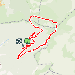

Length
21 km

Max alt
1674 m

Uphill gradient
950 m
Km-Effort
34 km

Min alt
1004 m

Downhill gradient
947 m
Boucle
Yes
Creation date :
2019-05-16 07:06:58.155
Updated on :
2019-05-16 17:03:41.874
7h59
Difficulty : Easy

FREE GPS app for hiking
 SityTrail
IGN / Geographical institutes
SityTrail Plus
The world is yours!
About
Trail Walking of 21 km to be discovered at Auvergne-Rhône-Alpes, Drôme, Romeyer. This trail is proposed by Joel26400.
Positioning
Country:
France
Region :
Auvergne-Rhône-Alpes
Department/Province :
Drôme
Municipality :
Romeyer
Location:
Unknown
Start:(Dec)
Start:(UTM)
693470 ; 4964376 (31T) N.
Comments