


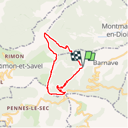
Barnave

ajd26
User

Length
12.5 km
Boucle
Yes
Creation date :
2019-05-16 07:17:20.0
Updated on :
2019-05-16 17:08:10.108
6h46
Difficulty : Difficult

FREE GPS app for hiking
 SityTrail
IGN / Geographical institutes
SityTrail Plus
The world is yours!
About
Trail Walking of 12.5 km to be discovered at Auvergne-Rhône-Alpes, Drôme, Barnave. This trail is proposed by ajd26.
Description
Barnave, col de Pennes, la Pâle 1340m puis les crêtes en direction du pas de la lune et ensuite le pas du soleil très joli panorama
Positioning
Country:
France
Region :
Auvergne-Rhône-Alpes
Department/Province :
Drôme
Municipality :
Barnave
Location:
Unknown
Start:(Dec)
Start:(UTM)
686726 ; 4947605 (31T) N.
Comments