


20190516 Brionne Harcourt

Childebert
User
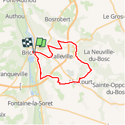

Length
23 km

Max alt
145 m

Uphill gradient
288 m
Km-Effort
26 km

Min alt
57 m

Downhill gradient
288 m
Boucle
Yes
Creation date :
2019-05-16 07:37:01.767
Updated on :
2019-05-16 18:52:14.166
6h51
Difficulty : Medium

FREE GPS app for hiking
 SityTrail
IGN / Geographical institutes
SityTrail Plus
The world is yours!
About
Trail Walking of 23 km to be discovered at Normandy, Eure, Brionne. This trail is proposed by Childebert.
Positioning
Country:
France
Region :
Normandy
Department/Province :
Eure
Municipality :
Brionne
Location:
Unknown
Start:(Dec)
Start:(UTM)
334010 ; 5451497 (31U) N.
Comments