


utgtrack-16564

attitude73
User
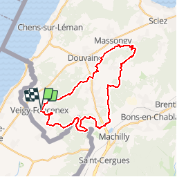

Length
31 km

Max alt
731 m

Uphill gradient
492 m
Km-Effort
37 km

Min alt
428 m

Downhill gradient
493 m
Boucle
Yes
Creation date :
2019-05-17 15:00:38.267
Updated on :
2019-05-17 15:00:38.267

FREE GPS app for hiking
 SityTrail
IGN / Geographical institutes
SityTrail Plus
The world is yours!
About
Trail of 31 km to be discovered at Auvergne-Rhône-Alpes, Upper Savoy, Veigy-Foncenex. This trail is proposed by attitude73.
Positioning
Country:
France
Region :
Auvergne-Rhône-Alpes
Department/Province :
Upper Savoy
Municipality :
Veigy-Foncenex
Location:
Unknown
Start:(Dec)
Start:(UTM)
288789 ; 5127628 (32T) N.
Comments