


mandrevillars

jacthiry
User
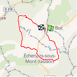

Length
6.6 km

Max alt
414 m

Uphill gradient
114 m
Km-Effort
8.1 km

Min alt
353 m

Downhill gradient
112 m
Boucle
Yes
Creation date :
2019-05-15 12:47:30.382
Updated on :
2019-05-17 15:51:21.233
1h54
Difficulty : Very easy

FREE GPS app for hiking
 SityTrail
IGN / Geographical institutes
SityTrail Plus
The world is yours!
About
Trail Walking of 6.6 km to be discovered at Bourgogne-Franche-Comté, Haute-Saône, Mandrevillars. This trail is proposed by jacthiry.
Positioning
Country:
France
Region :
Bourgogne-Franche-Comté
Department/Province :
Haute-Saône
Municipality :
Mandrevillars
Location:
Unknown
Start:(Dec)
Start:(UTM)
332972 ; 5275522 (32T) N.
Comments