


9917328-AUBRAC 2019 - 9 - RaG

mic-13
User
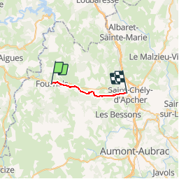

Length
13.8 km

Max alt
1156 m

Uphill gradient
321 m
Km-Effort
18 km

Min alt
962 m

Downhill gradient
296 m
Boucle
No
Creation date :
2019-05-18 08:06:38.731
Updated on :
2019-05-18 08:07:17.175
3h52
Difficulty : Medium

FREE GPS app for hiking
 SityTrail
IGN / Geographical institutes
SityTrail Plus
The world is yours!
About
Trail Walking of 13.8 km to be discovered at Occitania, Lozère, Fournels. This trail is proposed by mic-13.


Positioning
Country:
France
Region :
Occitania
Department/Province :
Lozère
Municipality :
Fournels
Location:
Unknown
Start:(Dec)
Start:(UTM)
509532 ; 4962593 (31T) N.
Comments