


PETIT SOM

oliviergau
User
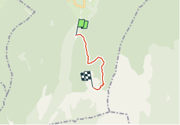

Length
2.8 km

Max alt
1753 m

Uphill gradient
615 m
Km-Effort
9 km

Min alt
1130 m

Downhill gradient
2 m
Boucle
No
Creation date :
2019-05-18 17:18:21.635
Updated on :
2019-05-18 17:18:21.635
--
Difficulty : Unknown

FREE GPS app for hiking
 SityTrail
IGN / Geographical institutes
SityTrail Plus
The world is yours!
About
Trail Touring skiing of 2.8 km to be discovered at Auvergne-Rhône-Alpes, Isère, Saint-Christophe-sur-Guiers. This trail is proposed by oliviergau.
Positioning
Country:
France
Region :
Auvergne-Rhône-Alpes
Department/Province :
Isère
Municipality :
Saint-Christophe-sur-Guiers
Location:
Unknown
Start:(Dec)
Start:(UTM)
719094 ; 5031250 (31T) N.
Comments