Villerest

kronio
User
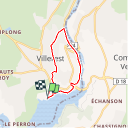

Length
5 km

Max alt
372 m

Uphill gradient
117 m
Km-Effort
6.5 km

Min alt
273 m

Downhill gradient
110 m
Boucle
Yes
Creation date :
2014-12-10 00:00:00.0
Updated on :
2014-12-10 00:00:00.0
--
Difficulty : Medium

FREE GPS app for hiking
 SityTrail
IGN / Geographical institutes
SityTrail Plus
The world is yours!
About
Trail Walking of 5 km to be discovered at Auvergne-Rhône-Alpes, Loire, Villerest. This trail is proposed by kronio.
Description
Boucle des deux ponts


Positioning
Country:
France
Region :
Auvergne-Rhône-Alpes
Department/Province :
Loire
Municipality :
Villerest
Location:
Unknown
Start:(Dec)
Start:(UTM)
580238 ; 5092811 (31T) N.
Comments