


Tatras 4

oliviergau
User
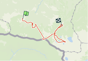

Length
15 km

Max alt
1951 m

Uphill gradient
1168 m
Km-Effort
30 km

Min alt
1339 m

Downhill gradient
1014 m
Boucle
No
Creation date :
2019-05-18 17:20:06.157
Updated on :
2019-05-18 17:20:06.157

FREE GPS app for hiking
 SityTrail
IGN / Geographical institutes
SityTrail Plus
The world is yours!
About
Trail of 15 km to be discovered at Lesser Poland Voivodeship, Tatra County. This trail is proposed by oliviergau.
Positioning
Country:
Poland
Region :
Lesser Poland Voivodeship
Department/Province :
Tatra County
Municipality :
Giewont
Location:
Unknown
Start:(Dec)
Start:(UTM)
423715 ; 5455739 (34U) N.
Comments