


Abbaye de Chaalis 01

JJDOLLE
User
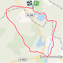

Length
8.5 km

Max alt
127 m

Uphill gradient
103 m
Km-Effort
9.9 km

Min alt
69 m

Downhill gradient
106 m
Boucle
Yes
Creation date :
2019-05-04 14:31:11.509
Updated on :
2019-05-19 09:08:11.006
2h37
Difficulty : Medium

FREE GPS app for hiking
 SityTrail
IGN / Geographical institutes
SityTrail Plus
The world is yours!
About
Trail Walking of 8.5 km to be discovered at Hauts-de-France, Oise, Fontaine-Chaalis. This trail is proposed by JJDOLLE.
Positioning
Country:
France
Region :
Hauts-de-France
Department/Province :
Oise
Municipality :
Fontaine-Chaalis
Location:
Unknown
Start:(Dec)
Start:(UTM)
476867 ; 5443945 (31U) N.
Comments
ras