


tour aubrac 4 st chely laguiole

mhetpierre
User
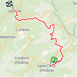

Length
25 km

Max alt
1347 m

Uphill gradient
845 m
Km-Effort
35 km

Min alt
839 m

Downhill gradient
687 m
Boucle
No
Creation date :
2019-05-19 14:08:26.106
Updated on :
2019-06-10 16:18:25.417
7h34
Difficulty : Very difficult

FREE GPS app for hiking
 SityTrail
IGN / Geographical institutes
SityTrail Plus
The world is yours!
About
Trail Walking of 25 km to be discovered at Occitania, Aveyron, Saint-Chély-d'Aubrac. This trail is proposed by mhetpierre.
Positioning
Country:
France
Region :
Occitania
Department/Province :
Aveyron
Municipality :
Saint-Chély-d'Aubrac
Location:
Unknown
Start:(Dec)
Start:(UTM)
494346 ; 4937746 (31T) N.
Comments