


De Montcey à Montcey

nicolasdresse
User
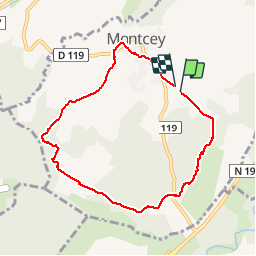

Length
7.3 km

Max alt
343 m

Uphill gradient
166 m
Km-Effort
9.5 km

Min alt
280 m

Downhill gradient
162 m
Boucle
Yes
Creation date :
2019-05-19 14:51:44.0
Updated on :
2019-05-19 17:06:04.643
2h13
Difficulty : Unknown

FREE GPS app for hiking
 SityTrail
IGN / Geographical institutes
SityTrail Plus
The world is yours!
About
Trail Walking of 7.3 km to be discovered at Bourgogne-Franche-Comté, Haute-Saône, Montcey. This trail is proposed by nicolasdresse.
Photos

Positioning
Country:
France
Region :
Bourgogne-Franche-Comté
Department/Province :
Haute-Saône
Municipality :
Montcey
Location:
Unknown
Start:(Dec)
Start:(UTM)
293033 ; 5281154 (32T) N.
Comments