


mont aurelien

bernir
User
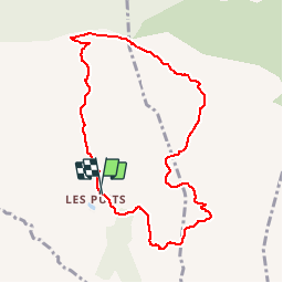

Length
9.1 km

Max alt
874 m

Uphill gradient
380 m
Km-Effort
14.2 km

Min alt
538 m

Downhill gradient
385 m
Boucle
Yes
Creation date :
2019-05-21 07:31:50.915
Updated on :
2019-05-29 21:56:52.486
2h55
Difficulty : Medium

FREE GPS app for hiking
 SityTrail
IGN / Geographical institutes
SityTrail Plus
The world is yours!
About
Trail Walking of 9.1 km to be discovered at Provence-Alpes-Côte d'Azur, Var, Pourrières. This trail is proposed by bernir.
Positioning
Country:
France
Region :
Provence-Alpes-Côte d'Azur
Department/Province :
Var
Municipality :
Pourrières
Location:
Unknown
Start:(Dec)
Start:(UTM)
724434 ; 4812665 (31T) N.
Comments